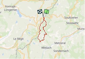
Le Sentier des Roches

Michel1963
User GUIDE

Length
20 km

Max alt
1355 m

Uphill gradient
1043 m
Km-Effort
34 km

Min alt
803 m

Downhill gradient
1043 m
Boucle
Yes
Creation date :
2020-07-22 07:31:31.204
Updated on :
2020-07-22 15:24:01.59
7h43
Difficulty : Difficult

FREE GPS app for hiking
 SityTrail
IGN / Geographical institutes
SityTrail Plus
The world is yours!
About
Trail Walking of 20 km to be discovered at Grand Est, Vosges, Le Valtin. This trail is proposed by Michel1963.
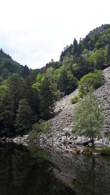
Photos


Positioning
Country:
France
Region :
Grand Est
Department/Province :
Vosges
Municipality :
Le Valtin
Location:
Unknown
Start:(Dec)
Start:(UTM)
352648 ; 5325307 (32U) N.
Comments